Pages

Showing posts with label Coastal Protection. Show all posts

07/06/2016

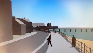
Possible Coastal Protection Measures between Grassy Beach and Broughty Ferry Castle - Flyover Simulation

Simulated View of Possible Coastal Defences Broughty Ferry June 2016
Simulated view of possible enhanced sea
defences for Broughty Ferry
If you missed the drop-in consultation on Wednesday 1st June 2016 about the proposed coastal protection measures between the Grassy Beach and Broughty Ferry Castle, you may the video flyover simulation of possible design for the scheme helpful - click on link below. 

Don't worry that you have missed out on the opportunity to respond to the Council. According to senior Council staff present at the drop-in event, this was an initial consultation which will be followed by the formal consultation. I'll try to keep constituents updated when we reach that point.

Link to video flyover simulation of possible changes to coastal defences Grassy Beach to Broughty Ferry Castle June 2016

24/05/2016

Consultation on Stannergate to Broughty Ferry Harbour Coastal Protection Measures Wed 1st June 10:00 - 20:00

Click on map to enlarge
A drop-in consultation about the proposed coastal protection measures between the Stannergate and Broughty Ferry harbour has been scheduled between 10am and 8pm on Wednesday 1st June 2016 at Broughty Castle Bowling Club, 439 King Street, Broughty Ferry DD5 2HA 

You and your friends and neighbours may want to take advantage of the opportunity to see the proposals at the drop-in exhibition and make up your minds how you wish to respond to the Council's enhanced sea defences.

The need for raised coastal defences follow the publication by the Scottish Environment Protection Agency (SEPA) of  enhanced definition maps of flood risks in Scotland.

These maps show that both banks of the Tay estuary are rated as 'high risk' for potential coastal flooding as is the Dighty as it flows through the Ferry Ward.

Residents who live in Fisher Street and Beach Crescent have already had water lapping almost to the top of the rows of sandbags last year. The residents of Balmossie Mill in Panmurefield know to their cost the threat that the Dighty in spate can pose to their homes.

Click on this link to go to the online flood maps.

20/01/2015

Public Consultation - Reshaping the Dunes BFerry Beach - Drop In Wed 21 January 2 - 8 pm Castle Green Centre

Plan of proposed alterations to the dunes at Broughty Ferry Beach
Click on plan to enlarge
On Wednesday 21 January Broughty Ferry residents and traders have the opportunity to find out more about the City Council's planning application to alter the shape and reinforce the base of the dunes at Broughty Ferry beach. This is one of a series of coastal protection measures the Council is bringing forward to minimize the risk of flooding along the Dundee City coastline. 

There will be a drop-in Consultation Event at the Castle Green Leisure Centre, St Vincent Street, Broughty Ferry between 2-8pm on Wednesday 21 January 2015. The event will provide residents and other interested parties an opportunity to look through drawings and details associated with the proposals as well as the opportunity to ask questions on the day.  

The public consultation period for the application is to be extended until Wednesday 4 February at 5pm to allow for any further comments after this event.

The full details of the planning application are as follows:
Reshaping, increased height, planting and formation of access points on the existing Dune system at the Esplanade, Broughty Ferry. Works to include for screened defence works at base of dunes on seaward side. Planning Application Ref: 14/00761/FULL
Link to Planning Application Documents and Plans