Pages

Showing posts with label Flooding Risk. Show all posts

10/07/2016

Flooding Again at Junction of Cedar Road and Forthill Road

Early evening yesterday, after a squally rain shower, there was once again flooding at the bottom of Cedar Road close to the junction with Forthill Road. I was on my way home from a social event and stopped to record what I could see.

As you can see from the video, liquid is pouring up out of the drains. Less obvious is that with the rain water run off in the drains there is also unpleasant and unhealthy household sewage which is also being flushed out of the drains onto the roadway and pavement. On the basis of previous flooding episodes at this location, it is most likely that when the waters subside, there will be sewage residues on the road and pavement.

I have informed Scottish Water and the City Engineers.

Now that the Council and other regional partners has a Flood Risk Plan, and an area such as this which is frequently subject to flooding shouldn't be ignored any longer. I hope that the drainage system will be enhanced to cope with current and future peak flows of domestic sewage and waste water as well as the rain water run off from Cedar Road and Forthill Road. 

More immediately, I have asked Scottish Water to clean up the area and remove sewage residues from the road and pavement once the flood waters have drained.

18/06/2016

Broughty Ferry Flood Protection Scheme - Exhibition Material Available Online

Flood Risk Map Broughty Ferry 2016
Click on map to enlarge
If you missed the Drop-In Consultation day in Broughty Ferry, you can still find out more about the Council's initial proposals for Flood Protection Measures in Broughty Ferry (Grassy Beach to the Esplanade).

The Council's presentation to the community council meeting on 7th June and the exhibition material from the drop-in consultation on 1st June are currently on display at the foyer of Dundee House,50 North Lindsay Street Dundee DD1 1QE . The exhibition material will be on display until Friday 24th June. Any person wishing to view the material and requires further explanation should ask for Gavin Smith or Michael Sandeman at reception.

Staff have also uploaded a video of the 3D animation to YouTube at the following link: https://youtu.be/GDcCvSrCVxw

They have also created a webpage on Dundee city Council's website where more detailed drawings can be viewed:
https://www.dundeecity.gov.uk/BroughtyFerryFloodProtection

07/06/2016

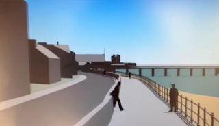
Possible Coastal Protection Measures between Grassy Beach and Broughty Ferry Castle - Flyover Simulation

Simulated View of Possible Coastal Defences Broughty Ferry June 2016
Simulated view of possible enhanced sea
defences for Broughty Ferry
If you missed the drop-in consultation on Wednesday 1st June 2016 about the proposed coastal protection measures between the Grassy Beach and Broughty Ferry Castle, you may the video flyover simulation of possible design for the scheme helpful - click on link below. 

Don't worry that you have missed out on the opportunity to respond to the Council. According to senior Council staff present at the drop-in event, this was an initial consultation which will be followed by the formal consultation. I'll try to keep constituents updated when we reach that point.

Link to video flyover simulation of possible changes to coastal defences Grassy Beach to Broughty Ferry Castle June 2016

24/05/2016

Consultation on Stannergate to Broughty Ferry Harbour Coastal Protection Measures Wed 1st June 10:00 - 20:00

Click on map to enlarge
A drop-in consultation about the proposed coastal protection measures between the Stannergate and Broughty Ferry harbour has been scheduled between 10am and 8pm on Wednesday 1st June 2016 at Broughty Castle Bowling Club, 439 King Street, Broughty Ferry DD5 2HA 

You and your friends and neighbours may want to take advantage of the opportunity to see the proposals at the drop-in exhibition and make up your minds how you wish to respond to the Council's enhanced sea defences.

The need for raised coastal defences follow the publication by the Scottish Environment Protection Agency (SEPA) of  enhanced definition maps of flood risks in Scotland.

These maps show that both banks of the Tay estuary are rated as 'high risk' for potential coastal flooding as is the Dighty as it flows through the Ferry Ward.

Residents who live in Fisher Street and Beach Crescent have already had water lapping almost to the top of the rows of sandbags last year. The residents of Balmossie Mill in Panmurefield know to their cost the threat that the Dighty in spate can pose to their homes.

Click on this link to go to the online flood maps.

22/12/2012

Dighty Burn in Spate in Broughty Ferry

Balmossie Mill on a fine day
On Friday, I was very concerned to learn that the Dighty Burn was in spate in Broughty Ferry. After another period of sustained torrential rain, rising water levels had been threatening to flood some of my constituents at Balmossie Mill. 

There isn't a good time to be flooded but clearly this must be a particularly difficult time. Being on flood watch in your own home just how probably means that elaborate Christmas holiday plans are disrupted and some services, you need to contact, may be slower to respond than usual as personnel are away from their desks on extended leave for Christmas and New Year. 

As well as dealing with any immediate requests for help, I shall be trying to see what the Council and Scottish Water can do to help ensure that rising water levels are better managed and homes are better protected in the future.

02/11/2012

Superstorm Sandy and Coastal Flooding Risks in Dundee

Click on map to enlarge
In a week when we see pictures of the devastation from flood damage caused by Superstorm Sandy in New York, I think it's certainly time to be asking how well prepared are we in Dundee to meet the potential challenge from storm damage and rising sea levels.

The Scottish Environmental Protection Agency (SEPA) have stated that:
'From the National Flood Risk Assessment we have found that one in 22 of all residential properties and one in 13 of all non-residential properties are at risk of flooding from rivers, the sea or heavy rainfall in urban areas.'


The extract (above left) from the National Flood Risk Assessment map, which is available online, broadly indicates that the City Centre and waterfront and central Broughty Ferry are the coastal areas of Dundee most at risk of flooding. But this map doesn't identify risks to individual homes and businesses. That will come from further studies.

I am relieved therefore to be informed that at long last the Stage 2 Coastal Flood Study which the council commissioned from external consultants will be presented to Committee before the end of the year and a briefing for all City Councillors has been arranged for later this month. Before the election in May 2012, I was assured that this survey report would be reported to Council after the election but before the summer recess. The recent storm destruction and disruption in the USA and in other parts of the UK remind us that we should not be waiting for a devastating storm to hit Dundee's coast before we make contingency plans and make improvements to protect the homes and livelihoods of our constituents.

At a recent meeting of the Planning Committee, when outline planning consent for the V and A was granted, I had asked senior planning officers at the meeting whether rising sea levels had been taken into account in determining the level of the proposed building on its site. We were informed that the site level had taken into account a potential rise in sea levels between 1 to 1.5 metres (3ft 3 inches to 4ft 11 inches in imperial measurements).

As a Ferry Councillor, I am obviously aware of the problems of flooding from high tides in stormy conditions that lap up close to properties near the Lifeboat shed. But add another four or five feet to sea levels and exceptionally at a spring tide with a following wind many more homes and businesses could be vulnerable to flooding and at depths that might necessitate evacuation. I think many folk in central Broughty Ferry living close to the river will be wondering what is in store, what the Council will be doing about this and when will they start work on beefing up our coastal protection.
 
I have written to the Chief Executive, David Dorward, about these issues and requested clarification about what improvements to coastal protection in City Quay and Broughty Ferry will be made."

Maryfield Councillor Georgia Cruickshank adds:
This will be worrying news for my constituents in City Quay who have bought properties or developed businesses close to the Tay. It would seem that that their homes and premises will be exposed to the risks of rising sea levels and an increased risk of coastal flooding. I hope the Council will be revealing adequate plans to reassure my constituents that they will be protected. Clearly as sea levels are rising there is a threat to coastal properties and my constituents and many local businesses will be in the front line.